About Marine Navigation - Denmark - Offline Gps Nautical Charts for Fishing, Sailing and Boating
GPS Marine Charts App offers access to charts covering Denmark. First marine GPS app to have route assistance with Voice Prompts for marine navigation. You can create new boating routes or import existing GPX/KML routes....
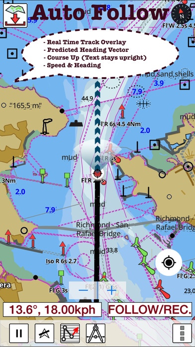
GPS Marine Charts App offers access to charts covering Denmark. First marine GPS app to have route assistance with Voice Prompts for marine navigation. You can create new boating routes or import existing GPX/KML routes. It supports Nautical Charts course up orientation. Includes Tide & Currents prediction. FEATURES Download Beautiful & detailed Hardware/GPU accelerated vector charts (text stays upright on rotation) Query details of Maritime object (Buoy, Lights, Obstruction etc). Custom depth(Ft/Fathom/Meter) & distance units (km/mi/NM) Custom Shallow Depth. Record tracks, Autofollow with real-time track overlay & predicted path vector. Voice Prompts for marine navigation (requires GPS ) 1ft / 3ft depth contour maps for anglers for selected lake maps. Useful for fishing/trolling(freshwater/saltwater). Supports GPX/KML for boating route editing/import. Tide & Currents. Seamless chart quilting. Map details from Coastal, Approaches,Harbour, Inland Encs(rivers), and general ENC (Electronic Marine Charts) are automatically mapped to correct zoomlevel Enter / import Waypoints. MAPS Get all the details that you find in your chartplotters! Denmark((derived from KMS/GST (Kort & Matrikelstyrensen / Geodatastyrelsen (GST)data)) ROUTE MANAGEMENT / TRIP PLANNING Create New /Edit Routes Reverse Routes Enter,Move, Add, Delete, Rename Waypoints Import GPX, KML & KMZ files Plot/Edit Routes Share/Export Routes, Tracks & Markers GPS FEATURES Auto Follow * Real Time Track Overlay * Predicted Path Vector * Course Up (Text stays upright) * Speed & Heading Route Assistance With Voice Prompts * Prompts when approaching a boating route marker * Continous distance & ETA updates * Alerts when sailing/boating off route * Alerts when boating in wrong direction Record Tracks TIDE & CURRENTS * For US, Canada, UK,Germany&New Zealand * High/Low Tides * Tidal Current Prediction * Active Current Stations CHARTS INCLUDED Aabenraa Fjord Aalborg Aalborg Bugt Als Sund og S nderborg Fjord rhus Bugt rhus Havn B lthavet Bornholmsgat Danmark med omgivende farvande Danmark. S gr nser Fakse Bugt og Pr st Fjord Farvandet nord for Fyn Femer B lt Flensborg Fjord Gedser Rev og Kadetrenden Gr dyb Guldborg Sund Haderslev Fjord Hjelm Bugt og Fakse Bugt Horns Rev Horsens Fjord Isefjord Kalundborg Fjord Karreb k Fjord Kattegat Kattegat, syd stlige del K benhavns Havn Lilleb lt, nordlige del Lilleb lt, sydlige del og Farvandet syd for Fyn Limfjorden. Aalborg - L gst r, Hals - Aalborg, Hals - Aalborg , Mors - L gst r , Thybor n - Mors Mariager Fjord Nakskov Fjord Nords en, Bl vands Huk - Fan Nords en, Fan - Sylt Nords en, Jyllands Vestkyst Odense Fjord resund, nordlige del sters en, Femern B lt - Sundet sters en, W-del Randers Fjord Ringk bing Fjord Roskilde Fjord, Fredrikssund - Roskilde Roskilde Fjord, Lyn s - Frederikssund Rudk bing L b Skagerrak Sm landsfarvandet stlige del Sn vringen og Kolding Fjord Storeb lt, nordlige del Storeb lt, Sprog - Langeland Storeb lt, sydlige del Sundet, Midterste del Sundet, Sydlige del Svenborg Sund Vejle Fjord SHARING * Share tracks/routes/markers on Facebook & Twitter * Export tracks/routes/markers as compressed GPX files. Instrumentation Marine AIS & (NMEA AIS and GPS over TCP/UDP) Wind direction & Speed,Sonar depth,Water temperature Change background to Satellite Imagery PLEASE NOTE: Continued use of GPS running in the background can dramatically decrease battery life.
Requires iOS 7.0 or later. Compatible with iPhone, iPad, and iPod touch.
Previous Versions
Here you can find the changelog of Marine Navigation - Denmark - Offline Gps Nautical Charts for Fishing, Sailing and Boating since it was posted on our website on 2016-11-05 01:42:03.
The latest version is 60.0.0 and it was updated on 2024-04-22 19:05:35. See below the changes in each version.
Marine Navigation - Denmark - Offline Gps Nautical Charts for Fishing, Sailing and Boating version 60.0.0
Updated At: 2013-10-08
Disclaimer
Official App Store Link
We do not host Marine Navigation - Denmark - Offline Gps Nautical Charts for Fishing, Sailing and Boating on our servers. We did not scan it for viruses, adware, spyware or other type of malware. This app is hosted by Apple and passed their terms and conditions to be listed there. We recommend caution when installing it.
The App Store link for Marine Navigation - Denmark - Offline Gps Nautical Charts for Fishing, Sailing and Boating is provided to you by apps112.com without any warranties, representations or guarantees of any kind, so access it at your own risk.
If you have questions regarding this particular app contact the publisher directly. For questions about the functionalities of apps112.com contact us.